
Flarebright unveils Tactera, strike grade GNSS free navigation
The UK’s Flarebright has unveiled Tactera, a new high accuracy, strike-grade absolute navigation system that operates independently of satellite navigation systems during a demonstration held on the 27th of March.
During the demonstration, Flarebright demonstrated the ability of three GNSS-free navigation systems to improve the positioning of a small swarm of drones. Three drones were flown over Shuttleworth Airfield in a passive test. “A passive test is where the back-up navigation system is logging a response during the flight. So, it is running in parallel with the absolute positioning (GPS). The GPS is doing proper, safe navigation, but the log of the back up navigation system is monitoring what it would be doing on its own,” Dr Carl Sequeira, Flarebright’s head of engineering told the audience on the 27th March.
The results of the demonstration were shown to attendees on screens, with the slow whine of three fixed wing drones orbiting overhead. The oval-shaped flight pattern of each drone was clearly demonstrated along with a graph indicating the accumulating drift of their inertial navigation sensors. “If the drones were flying without GPS and relying only on inertial navigation, their behaviour would become increasingly erratic, zig-zagging back and forth until they crashed,” Dr Sequeira said.
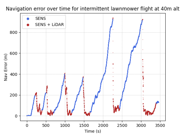
This graph shows how the LiDAR works with Flarebright’s software enhanced navigation system, which is called Intera, to re-baseline the the drone’s position, keeping the navigation error much lower than inertial navigation alone. Credit: FlarebrightThe graphs showed this effect to some extent, as they mapped the simulated position outside of the actual orbits of the drones. Periodically, however, the position accuracy would dramatically improve before gradually climbing again. This was the effect of the LiDAR (Light Detection and Ranging), which was comparing terrain ranging data with a Digital Elevation Model of the terrain at Shuttleworth that was uploaded to the drone’s computer.
In addition to the LiDAR navigation system, the Flarebright team also demonstrated a swarming navigation concept called Tactera Swarm. The three drones were fitted with radio frequency devices allowing them to share data with each other. “The idea came because you might have different systems, or different qualities of a system working together. So, we thought that you could improve their navigation by fusing their sensor data,” Dr Sequeira explained. The drones show-cased a significant improvement over the LiDAR only assisted flight when operating as a swarm. All three were able to share location data, improving all of their assessed positions.
“With the swarm, a single good terrain match can improve the estimate for all the systems in a swarm,” Dr Sequeira said.“ At least one drone has no LiDAR during the tests, so this could be one with LiDAR and two with Intera (a software enhanced inertial navigation system), for example.” Typically, Intera can drift up to 3.5 km in 30 minutes, but swarm fusion with LiDAR can correct the drift back down to under 10m accuracy.
Rapid development

The Tactera demonstration was accompanied by a live demo of Extera, the flight termination system. It is shown here, deploying a parachute after power was cut to a drone. Credit: Flarebright
Tactera has been developed over the past 12 months following a series of engagements with the UK’s Research and Development, Test and Evaluation team which provided one of the Front Line Commands (Army, Navy, or Air Force) with the opportunity to see Flarebright’s Intera system in operation. This led to a request for a demonstration of Intera on an operational system as well as something LiDAR-based. However, there was one slight snag with this, and that is a familiar problem to the UK’s drone developers; training estate. The UK’s training ranges that allow drones to be flown are too small to test new navigation systems as there is a risk that the drones will leave the training area and fly into a civilian one.
Flarebright set out to address this problem too, developing a new flight termination system called Extera. This is a platform agnostic system designed to cut the power to a drone if it is exhibiting unexpected flight behaviour, about to leave a geofence, or do something else that could prove dangerous. “Most flight termination systems are bespoke to the aircraft and rely on the flight control system of the vehicle, so how can you guarantee that you can terminate something within the right period of time if it is a prototype?” Dr Sequeira questioned.
Shortly after, a member of the audience was invited to press a switch on the flight termination system; the whine of the drone engine that was arching its way slowly through the sky suddenly stopped and it began a steep descent towards the ground. A parachute deployed once it had picked up speed and the drone landed softly on the grass.
Flarebright is looking ahead to further development of Tactera through partnerships with drone manufacturers in a bid to operationally test the system. There are also plans to develop Extera further so that it can be tested on heavier vehicles.
Tech profile: Tactera

A flight of drones ready for the Flarebright demonstration in the UK. The company has developed all of the solutions that were demonstrated in the past 12 months. Credit: Flarebright
Tactera is available in three configurations: Tactera, which is just the LiDAR solution, Tactera Marine, combining the LiDAR with Intera for long, open-water crossings, and Tactera Swarm, which combines all of Flarebright’s navigation solutions with the swarm navigation capability. Intera exploits surplus data generated by a drone that is generally wasted. This might include things like the RPM of the motors or commands from the flight control unit. The Flarebright team extracts up to a minute of flight data from the drone and then builds a digital model based on the surplus data combined with a set of machine learning algorithms built by the company that design a software solution optimised for the drone in question. This software is uploaded to the drone’s computer and used to correct the positioning error of its inertial navigation system.
In contrast, Tactera maintains platform independence by using LiDAR or radar altimeter measurements from the drone to the ground that are combined with a digital map plus an estimated velocity, altitude, and attitude of the drone. That data is fed into a type of algorithm that is used to approximate a system’s state using incomplete data. Knowing where the drone started out, how far it has approximately travelled (velocity), which direction it is facing (attitude), and how high it is (altitude), the algorithm assesses the data collectively to give an estimation of the drone’s position based on which measurements are assessed to be most accurate. This process is repeated periodically throughout the flight allowing the drone’s computer to continually reassess its location and adjust its path as necessary.
“Flight tests were conducted in Spain and it [Tactera] achieved accuracy of around 30 m,” Dr Sequeira explained. This is quite significant, the terrain matching system of a Tomahawk Land Attack Cruise Missile can achieve an accuracy of around 10 m, but at a much higher cost. “It’s important to note that the LiDAR system is a very early prototype with lots of scope for improvement that will get the accuracy down to 10 metres,” Kelvin Hamilton, Flarebright’s CEO explained after the demonstration. “We also did tests to see how much error the LiDAR could correct. We found the LiDAR was able to cope with a navigation error of several hundred metres, such as would build up when crossing a long stretch of open water,” Dr Sequeira said.
In terms of hardware, Tactera is able to achieve its absolute position estimation with low-cost automotive LiDAR sensors, costing around £500, and weighing just 170 grams. “Terrain mapping is done all the time with cameras and multi-beam LiDAR. Typically this requires a heavy sensor and compute heavy system. However, our solution is much cheaper and lighter,” Dr Sequeira said. The computing element of Tactica has been demonstrated on a Raspberry Pi-3B, an affordable single-board computer around the size of a credit card and weighing just 45 grams. It has a very low power requirement, which means it can easily be integrated into many different drones allowing Tactera and Intera to be installed and operated.
When Tactera Swarm is used, the drones share their approximations with each other and use the highest weighted position as their shared truth. GPS can be periodically used to reseed their absolute position and then the LiDAR and Intera combination will work to keep that error down.
Calibre comment
The type of technology being developed by Flarebright is inherently dual use. There is no future in which drones can be expected to regularly deliver heavy parcels over a city if their navigation system can be knocked out by relatively inexpensive jammers, for instance. The same is true of civil organisations that might want to use drones to rapidly assess the best route to repair a road or resolve a traffic jam.
In the world of defence, however, Tactera is being positioned for a range of strike systems which must be able to survive and reach their target in a GNSS denied environment. Already, Russia has demonstrated the ability to degrade the accuracy of western GPS-reliant weapons to the point where they fail. This means that as the West looks to re-equip its armed forces, solutions that can provide sufficient accuracy without reliance on GPS might gain considerable interest.
By Sam Cranny-Evans, published on 11th April, 2025.


Sign Up for Updates!
Get insider news, tips, and updates. No spam, just the good stuff!